Welcome to the download page of Canada Maps, where Quebec with Names Map is free to download in printable JPG and PDF file formats. Whether you’re planning a road trip, researching a project, or want to understand better the political or geographical Canada, our collection of maps has got you covered.
About the Quebec with names map
Quebec is a province located in eastern Canada, known for its rich history, unique culture, and diverse landscapes. With its expansive territory spanning over 1.6 million square kilometers, an outline map can be a valuable tool for exploring and understanding the province’s major political and geographical features.
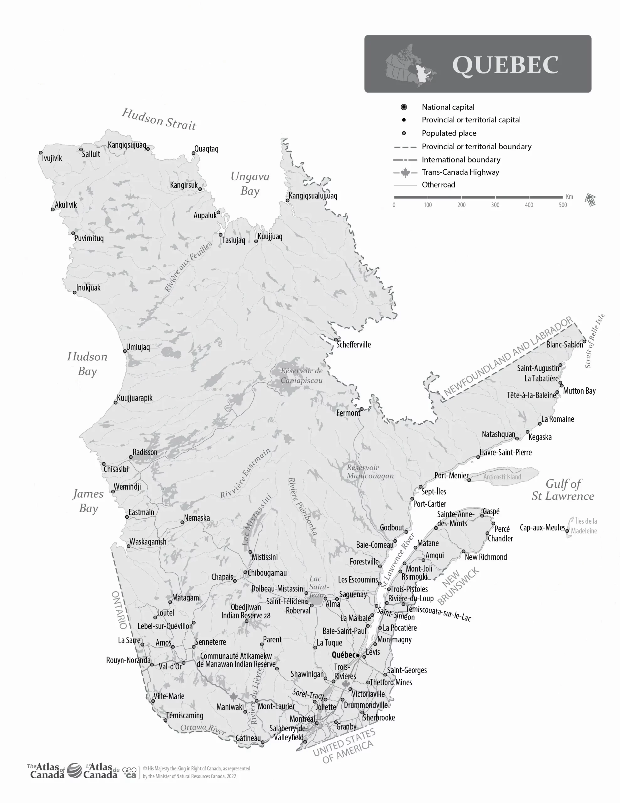
The map displays Quebec’s boundary, encompassing several geographic regions, including the Canadian Shield, the Appalachian Mountains, and the St. Lawrence Lowlands. The boundary is also home to many significant political features, such as regional county municipalities, cities, towns, and First Nations reserves, which the map labels to help orient visitors and researchers.
In addition to the boundary, the map shows Quebec’s coastline, which stretches over 5,000 kilometers along the Gulf of St. Lawrence and the Atlantic Ocean. The coastline is characterized by fjords, bays, and peninsulas that provide access to the sea, making it an important site for fisheries, transportation, and tourism. The map also highlights significant islands, including Anticosti Island, the Magdalen Islands, and the Iles-de-la-Madeleine, home to unique ecosystems, communities, and cultural heritage sites.
The map further identifies the province’s major lakes and rivers, including the St. Lawrence River, the primary waterway connecting the Great Lakes to the Atlantic Ocean. Other notable water bodies include Lake Mistassini, Lake Saint-Jean, and the Rupert River, which have been critical to the province’s economy, history, and environment.
To help orient visitors and researchers, the map labels significant cities and towns, such as Quebec City, Montreal, and Gatineau, as well as significant landmarks, such as Mont Tremblant, the Laurentian Mountains, and the Jacques Cartier National Park. These features provide insights into the province’s cultural and recreational offerings, as well as its natural resources and conservation efforts.
Overall, an outline map of Quebec with the names of major political and geographical features is a valuable resource for exploring and understanding the province’s diverse and dynamic landscapes, history, and culture.
The image is a black-and-white map of Quebec, a province in Canada. This map is presented in a high resolution, with dimensions of 1978 pixels in width and 2560 pixels in height, and it is in the WebP format.
As a black-and-white map, it focuses on Quebec’s geographical layout and features without using color. This includes the province’s extensive river systems, forests, and varied topography, from coastal areas to interior regions. The image’s high resolution ensures that these geographical details are clearly visible, making the map useful for various purposes such as educational studies, geographical analysis, or as a base for more detailed mapping projects.
The monochromatic presentation provides a clear and distinct view of Quebec’s geography, which can be particularly useful for certain types of analysis or for creating a specific aesthetic in presentations or publications.
Download link for Outline map Quebec with Names – English printable JPG.
Download link for Outline map Quebec with Names – English printable PDF.
Looking for more similar maps to Quebec with Names for printing? Check them out here.
Downloading these maps is easy and hassle-free. Select the map you want, choose the file format that works best for you, and hit the download button. These Canada-related maps are designed to be printer-friendly, so you can print them out at home or take them to a local print shop.
Use cases for the Quebec with Names Map
A map of Quebec with names of major political and geographical features can serve a variety of use cases for different audiences.
For tourists or visitors, the map can be a valuable guide to exploring the province’s diverse regions, landmarks, and activities. The map can help travelers plan their itineraries and navigate the area more easily and accurately by highlighting major cities, towns, and tourist attractions curacy. The map’s identification of natural features such as lakes, rivers, and national parks can also assist in planning outdoor activities such as hiking, canoeing, and skiing.
The map can serve as a valuable resource for researchers, educators, or students to study and teach Quebec’s geography, history, and culture. By labeling the province’s major political features, such as electoral districts, municipalities, and regional county municipalities, the map can provide insights into the social and political organization of the province. Identifying natural features such as rivers, mountains, and islands can also help researchers study the province’s geological history, climate, and biodiversity.
For businesses or organizations operating in Quebec, the map can be useful for market analysis, site selection, or resource planning. By identifying major infrastructure, transportation routes, and natural resources, the map can help companies identify potential opportunities or challenges associated with different locations or industries. This can assist in making informed decisions about investment, marketing, and other business activities.
For Quebecois residents, the map can be a valuable tool to understand the province’s different regions, history, and culture and explore their province. It can also serve as a guide for planning trips or activities within Quebec.
A map of Quebec with names of major political and geographical features is a versatile and essential resource for various audiences, including tourists, researchers, businesses, and residents.
We are committed to providing high-quality, informative maps accessible to everyone. These Canada maps are available for personal or educational purposes, and we encourage you to share them with your friends and colleagues.
Driving Directions, Google Maps, and more
To use these services, please visit the Driving Directions, Google Maps, or OpenStreetMap pages.
Provinces and territories
If you are looking for detailed information on the Canadian provinces and territories, consult the following pages: Alberta, British Columbia, Manitoba, New Brunswick, Newfoundland and Labrador, Northwest Territories, Nova Scotia, Nunavut, Ontario, Prince Edward Island, Quebec, Saskatchewan, and the Yukon.
The map of Quebec with the names above contains information licensed under the Open Government Licence – Canada.
Thank you for visiting Canada Maps! We hope our maps will help you explore and discover the beauty of Canada.