Prince Edward Island, one of Canada’s smallest provinces, is famous for its stunning natural beauty, warm hospitality, and rich cultural heritage. If you plan to visit this picturesque island, you’ll need a detailed road map to explore its charming towns, scenic routes, and historical landmarks. Our Prince Edward Island area road map is the perfect tool to help you easily navigate the island’s highways, byways, and back roads. This blog post will discuss why such maps are helpful and share exciting facts about the island.
Prince Edward Island Area Road Map
This map shows cities, towns, Trans-Canada highways, major highways, secondary roads, railways, and national parks in Prince Edward Island.
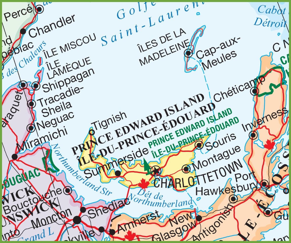
The Prince Edward Island area road map is a detailed depiction of the province’s roadways, presented at a resolution of 1000×835 pixels. It likely includes the main highways and secondary roads that connect the various communities across the island. The map is designed to assist travelers in navigating the smallest province of Canada, highlighting the routes to and from key destinations such as Charlottetown, Summerside, and the Confederation Bridge, which links PEI to the mainland. This map is an essential tool for anyone driving on Prince Edward Island, providing a clear and concise guide to the island’s road network.
Please visit this page for other map resources or Google Maps.
What are Prince Edward Island area road maps used for?
A good road map is essential for anyone planning a road trip or traveling to an unfamiliar destination. Our Prince Edward Island area road map provides detailed information about the island’s road network, including major highways, secondary roads, and local streets. You can use the map to plan your route, estimate travel times, and locate attractions, accommodations, and services. Our map will help you get where you want to go, whether driving, cycling, or walking.
Did you know about Canada’s smallest province?
Prince Edward Island is located on the east coast of Canada and is the country’s smallest province, covering an area of only 5,660 square kilometers. Despite its small size, the island is home to more than 150,000 people and attracts thousands of visitors yearly. The island’s capital city is Charlottetown, a charming and historic town that played a pivotal role in forming Canada as a nation. Other notable towns and cities on the island include Summerside, Kensington, and Montague.
The island is also famous for its natural beauty, including pristine beaches, rolling hills, and stunning coastal vistas. Some of the island’s most popular attractions include the Anne of Green Gables House, the Confederation Trail, and the Greenwich Dunes.
Conclusion
If you’re planning a trip to Prince Edward Island, our comprehensive road map is essential to help you navigate the island’s highways, byways, and back roads. You can use the map to plan your route, estimate travel times, and locate attractions, accommodations, and services. With detailed information about the island’s road network, our map will help you explore the island’s natural beauty, historic landmarks, and cultural treasures. So what are you waiting for? Start planning your trip to Prince Edward Island today!