Southern Saskatchewan is a vast region that offers visitors diverse experiences. From the bustling city of Regina to the tranquil natural beauty of Cypress Hills Interprovincial Park, there is something for everyone. To help you plan your visit, a comprehensive map of Southern Saskatchewan is available, highlighting all the essential locations, including national parks, historic sites, and tourist reception centers.
Map of Southern Saskatchewan
This map shows cities, towns, rivers, lakes, Trans-Canada highway, major highways, secondary roads, national parks, provincial parks, historic sites, ecological reserves, Indian reservations, regional parks, campgrounds, airports, ferries, tourism visitor reception centers and rest areas in Southern Saskatchewan.
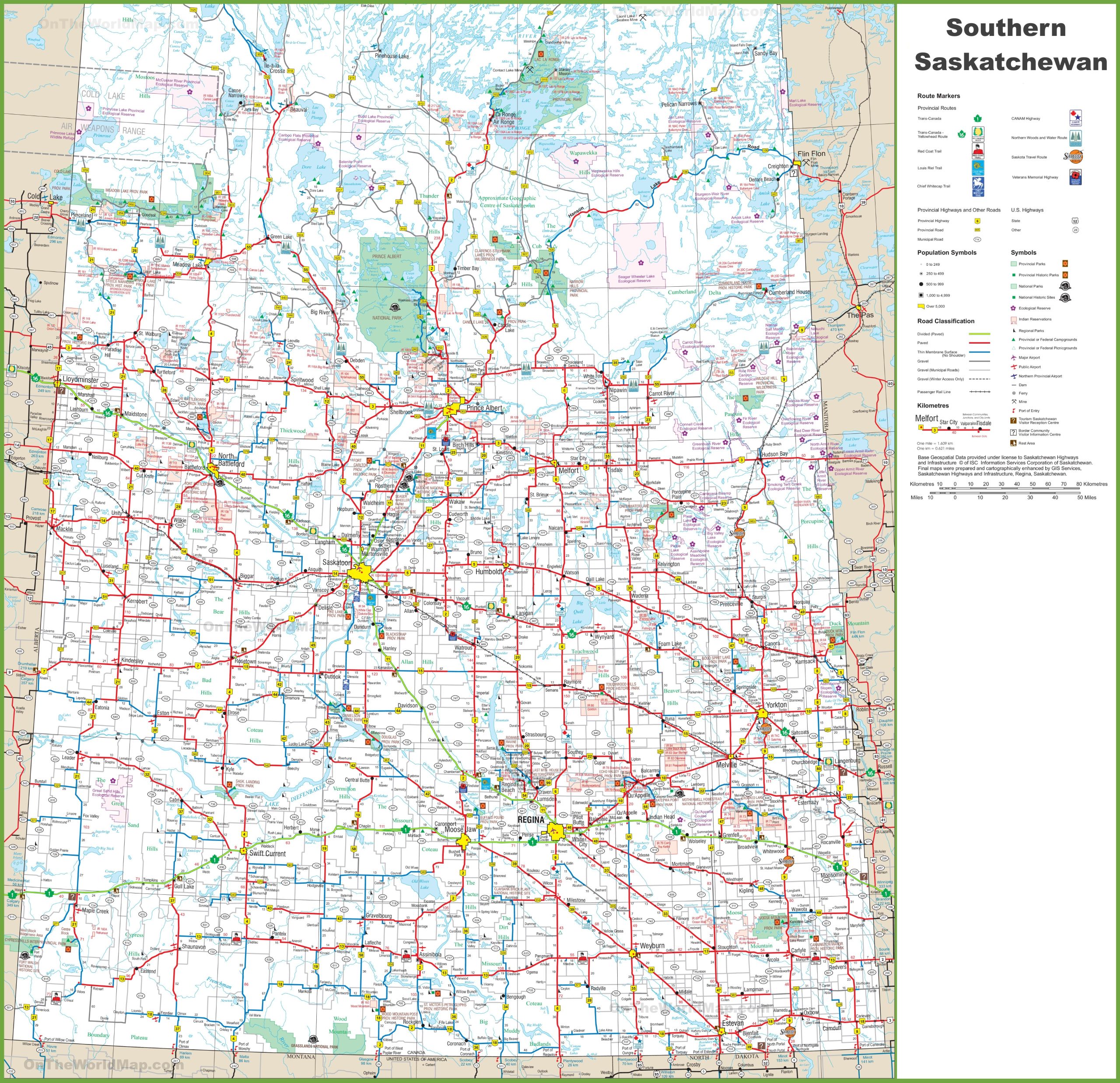
The map of Southern Saskatchewan is a detailed visual guide with a resolution of 2560×2474 pixels. It features a comprehensive layout of the province’s road network, including provincial highways and other roads, as well as U.S. highways that approach the border. The map is marked with symbols indicating population centers, provincial parks, historic sites, ecological reserves, and other points of interest. It also includes a road classification system, from primary paved roads to winter roads. Base geospatial data is provided under license to Saskatchewan Highways and Infrastructure, with final maps prepared by GIS Services in Regina, Saskatchewan. This map is a valuable tool for anyone looking to explore Southern Saskatchewan, from its rural landscapes to its urban centers.
Please visit this page for other map resources or Google Maps.
Here are some interesting facts about the highlighted routes on the Southern Saskatchewan map
- The Trans-Canada Highway, also known as Highway 1, stretches across Canada from Victoria, British Columbia, to St. John’s, Newfoundland, making it the longest national highway in the world. In Saskatchewan, the highway passes through the cities of Regina and Moose Jaw.
- The Trans-Canada Yellowhead Route, also known as Highway 16, runs through the northern part of Southern Saskatchewan, connecting the province to British Columbia and Manitoba. It is named after the Yellowhead Pass, a mountain pass in the Rocky Mountains.
- The Red Coat Trail, also known as Highway 13, follows the route of the historic North-West Mounted Police Trail, which the Mounties used in the late 1800s to establish law and order in the Canadian West.
- The Louis Riel Trail, also known as Highway 11, is named after Louis Riel, a prominent Métis leader who led two rebellions against the Canadian government in the late 1800s. The highway follows the historic Carlton Trail, which was a major trade route in the early days of the fur trade.
- The Chief Whitecap Trail, also known as Highway 219, is named after Chief Whitecap, a First Nations leader who played a vital role in establishing the city of Saskatoon. The trail connects Saskatoon to the US border and the city of Regina.
- The CANAM Highway, also known as Highway 2, runs north-south through the eastern part of Southern Saskatchewan, connecting the province to the US border and the state of Montana.
- The Northern Woods and Water Route, also known as Highway 55, runs through the northern part of Southern Saskatchewan, passing by several lakes and rivers that are popular fishing and outdoor recreation destinations.
- The Saskota Travel Route, also known as Highway 5, runs east-west through Southern Saskatchewan, passing through several small towns and connecting the cities of Saskatoon and Regina.
- The Veterans Memorial Highway, also known as Highway 6, runs north-south through the western part of Southern Saskatchewan, passing through several small towns and connecting the cities of Regina and Saskatoon. The highway is dedicated to the memory of Canadian veterans who served in wars and peacekeeping missions worldwide.
Explore Southern Saskatchewan’s Urban Centers
The map of Southern Saskatchewan provides visitors with an excellent resource to navigate the region’s urban centers. Regina, the provincial capital, is the largest city in Southern Saskatchewan and a hub for culture, history, and outdoor recreation. The map shows all the essential landmarks, including the Royal Saskatchewan Museum and the Saskatchewan Science Centre. Saskatoon, the largest city in the province, is also highlighted on the map. The city offers a range of cultural activities, including art galleries, museums, and theaters.
Discover the Natural Wonders of Southern Saskatchewan
Southern Saskatchewan has several national and provincial parks, and the map highlights all the essential locations. Cypress Hills Interprovincial Park is one of the most popular destinations in the region, offering a range of activities, including hiking, camping, and fishing. Grasslands National Park is another must-visit location, home to various wildlife, including bison, pronghorns, and coyotes.
Immerse Yourself in Southern Saskatchewan’s History and Culture
Southern Saskatchewan is steeped in history and culture, and the map highlights all the essential locations. Visitors can explore the region’s First Nations history and culture by visiting the Indian Head and Fort Qu’Appelle. The map also shows all the important historic sites, including the Tunnels of Moose Jaw, the RCMP Heritage Centre, and the Western Development Museum.
Plan Your Perfect Getaway with a Detailed Map
Visitors can plan their perfect getaway with the comprehensive map of Southern Saskatchewan. The map shows all the essential locations, including campgrounds, airports, and ferry crossings, making it easier to plan your trip. The map also highlights all the rest areas and tourist reception centers, providing visitors with up-to-date information about the region.
Conclusion
Southern Saskatchewan is a vast and diverse region that offers a range of experiences to visitors. The map of Southern Saskatchewan provides visitors with a comprehensive guide to exploring the region’s urban centers, natural wonders, history, and culture. Visitors can easily plan their perfect getaway with all the essential locations highlighted.