Home »

Yukon Relief Map – Explore Canada with ease using our printable maps!
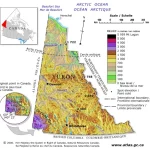
This map of Yukon provides a visual representation of the region’s diverse topography using hypsometric tints and spot elevations. It also shows significant lakes that are prominent in the region, which helps identify bodies of water in the area. The elevation data used in this map was derived from the highly acclaimed map Canada-Relief, Fifth Edition, National Atlas of Canada, published in 1986.