Home »

Where is Alberta?
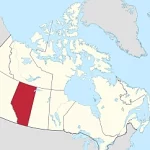
Located in the western part of Canada, Alberta is a province known for its stunning landscapes and natural beauty. Situated between the provinces of British Columbia and Saskatchewan, Alberta covers an area of over 660,000 square kilometers.
The geography of Alberta is incredibly diverse, with a mix of towering mountains, vast prairies, and pristine lakes. The iconic Canadian Rockies dominate the western part of the province, offering breathtaking views and opportunities for outdoor adventures like hiking and skiing.