Home »

Prince Edward Island Relief Map – Explore Canada easily using our printable maps!
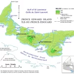
This relief map of Prince Edward Island provides a clear and accurate representation of the terrain, using hypsometric tints and spot elevations to represent different elevations. In addition to elevation data, the map also highlights the location of major lakes on the island, which play a crucial role in the island’s ecology, culture, and economy. The elevation ranges provided in the map legend are an essential feature of the map, providing viewers with a clear understanding of the different elevations represented by the various colors. This information is valuable for various applications, such as land use planning, geological studies, and environmental management.