Prince Edward Island with Names Map – Explore Canada with ease using our printable maps!
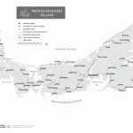
The map of Prince Edward Island shows the province’s boundary, coastline, lakes and rivers, cities and towns, and vital physical landmarks.
The Standard Time Zones Map of Canada is valuable for businesses, travelers, researchers, and educators. It helps people coordinate activities across different time zones and understand Canada’s unique time zone system. The post also explains Daylight Saving Time and the Provincial Times Zones in Canada.