map

Home » map » Page 2

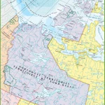
Navigate the Northwest Territories with Ease: A Comprehensive Road Map

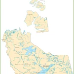
This map shows cities, towns, highways, main roads, secondary roads, rivers, and lakes in Northwest Territories. Cities, towns, counties, interprovince highways, Canada highways, province highways, main roads, secondary roads, rivers, lakes, airports, national parks, rest areas, welcome centers, Indian reservations, scenic byways, and points of interest in Northwest Territories. Hotels, resorts, beaches, national parks, rest areas, welcome centers, Indian reservations, scenic byways, points of interest, tourist attractions, and sightseeing in Northwest Territories.

Home » map » Page 2

Explore the Best of Labrador with Scenic Driving Routes

Labrador is a vast and breathtaking region in Canada, known for its rugged natural beauty, diverse wildlife, and fascinating cultural heritage. To explore this stunning destination, there’s no better way than hitting the open road and embarking on a scenic driving adventure. That’s where our Labrador Scenic Driving Routes Map comes in, helping you navigate … Read more

Home » map » Page 2

Explore the Beauty of Central Newfoundland with this Tourist Map

This map shows cities, towns, the Trans-Canada highway, secondary roads, national parks, provincial parks, campgrounds, provincial/national historic sites, airports, local ferries, summer ferries, ski areas, golf courses, and provincial visitor information centers in Central Newfoundland.

Home » map » Page 2

Experience the Best of Avalon with Scenic Driving Routes Map

This map shows cities, towns, trails, Trans-Canada highways, secondary roads, national parks, provincial parks, provincial visitor information centers, provincial/national historic sites, ferries, airports, and natural scenic attractions in Avalon.

Home » map » Page 2

Discover Central Newfoundland’s Scenic Beauty with our Driving Routes Map

This map shows cities, towns, trails, Trans-Canada highways, secondary roads, national parks, provincial parks, provincial visitor information centers, provincial/national historic sites, ferries, airports, and natural scenic attractions in Central Newfoundland.

Home » map » Page 2

Discover Eastern Newfoundland’s Natural Beauty with this Scenic Driving Route Map

This map shows cities, towns, trails, Trans-Canada highways, secondary roads, national parks, provincial parks, provincial visitor information centers, provincial/national historic sites, ferries, airports, and natural scenic attractions in Eastern Newfoundland.

Home » map » Page 2

Explore Eastern Newfoundland with a Comprehensive Tourist Map

This map shows cities, towns, the Trans-Canada highway, secondary roads, national parks, provincial parks, campgrounds, provincial/national historic sites, airports, local ferries, summer ferries, ski areas, golf courses, and provincial visitor information centers in Eastern Newfoundland.

Home » map » Page 2

Discover the Beauty of Western Newfoundland with Scenic Driving Routes

This map shows cities, towns, trails, Trans-Canada highways, secondary roads, national parks, provincial parks, provincial visitor information centers, provincial/national historic sites, ferries, airports, and natural scenic attractions in Western Newfoundland.

Home » map » Page 2

Explore Western Newfoundland with a Detailed Tourist Map

This map shows cities, towns, the Trans-Canada highway, secondary roads, national parks, provincial parks, campgrounds, provincial/national historic sites, airports, local ferries, summer ferries, ski areas, golf courses, and provincial visitor information centers in Western Newfoundland.